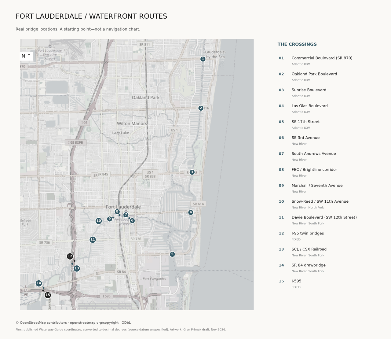
When I help a buyer compare waterfront homes in Fort Lauderdale, I look beyond the dock. The route to the ocean matters too: which bridges are on it, whether they open, and how their schedules fit the way you boat. Here’s a practical starting point for the Intracoastal and New River—not a substitute for current charts or the bridge tender’s instructions.
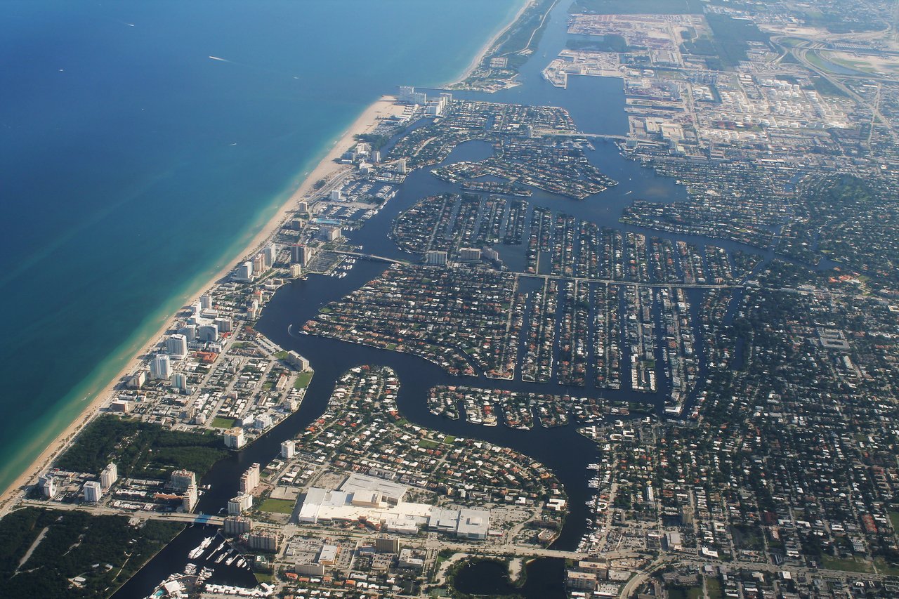
Photo: formulanone / Josh Lintz, “Fort Lauderdale Intracoastal Waterway Aerial,” 2012,
Historical context image, not current navigation imagery. Preview displays a cropped view; any image adaptation remains CC BY-SA 2.0.
Map pins are georeferenced from Waterway Guide’s published coordinates. Map artwork uses OpenStreetMap data with attribution; see research-notes.md. ICW and New River mile markers use different references and are not directly comparable.
Clearances are in feet, closed for movable bridges and permanently fixed for fixed bridges, generally above mean high water. NOAA’s 2026 Coast Pilot, chapter 12 ¶¶569–581 and 589, supplies the principal clearance figures. “Verify” marks a secondary-source value or unresolved discrepancy. On-signal means request an opening; it does not override the scheduled restrictions below.
# / Bridge | Waterway / statute mile | Closed or fixed clearance | Regular opening schedule | Source
1. Commercial Boulevard (SR 870)
Atlantic ICW / 1059.0
15 ft
Hour and half-hour (:00 / :30).
2. Oakland Park Boulevard
Atlantic ICW / 1060.5
22 ft
:15 and :45 each hour.
3. East Sunrise Boulevard (SR 838)
Atlantic ICW / 1062.6
25 ft
Hour and half-hour (:00 / :30). First weekend in May: need not open Sat/Sun 4–6 p.m.; first Saturday also 9:45–10:45 p.m.
4. East Las Olas Boulevard
Atlantic ICW / 1064.0
24 ft (reported at center)
:15 and :45 each hour. First weekend in May: need not open Sat/Sun 4–6 p.m.; first Saturday also 9:45–10:45 p.m.
5. SE 17th Street (Brooks Memorial)
Atlantic ICW / 1065.9
55 ft
Hour and half-hour (:00 / :30). Mon–Fri, except federal holidays, 6:50–9:10 a.m. and 3:50–6:10 p.m.: top of the hour only.
6. SE 3rd Avenue
New River / 1.4
16 ft
On signal, except Mon–Fri (excluding federal holidays), 7:30–9 a.m. and 4:30–6 p.m., when the draw need not open.
7. South Andrews Avenue
New River / 2.3
21 ft
On signal, except Mon–Fri (excluding federal holidays), 7:30–9 a.m. and 4:30–6 p.m., when the draw need not open. Inbound openings may also be withheld while the FEC draw is closed for a train.
8. FEC Railroad / Brightline corridor
New River / 2.5
4 ft
Normally open except rail traffic, authorized inspections/maintenance. No closure longer than 60 consecutive minutes. Required hourly 10-minute openings, 5 a.m.–11:59 p.m.; see detail below.
9. William H. Marshall (Seventh Avenue)
New River / 2.7
20 ft
On signal, except Mon–Fri (excluding federal holidays), 7:30–9 a.m. and 4:30–6 p.m., when the draw need not open.
10. SW 11th Avenue / Snow-Reed
New River, North Fork / 3.3 (guide)
3 ft — verify
On signal under the general drawbridge rule; no bridge-specific rush-hour restriction verified here.
11. Davie Boulevard (SW 12th Street)
New River, South Fork / 0.9
21 ft
On signal, except Mon–Fri (excluding federal holidays), 7:30–9 a.m. and 4:30–6 p.m., when the draw need not open.
12. I-95 twin bridges
New River, South Fork / 2.0 (guide; NOAA uses another reference)
55 ft — fixed
Does not open.
13. SCL / CSX railroad bridge
New River, South Fork / 2.0 (guide)
Unverified: NOAA 6 ft / guide 2 ft
General on-signal rule; guide describes normally open without train traffic. Confirm rail operations with the tender.
14. SR 84 drawbridge
New River, South Fork / 4.4
21 ft
On signal with at least 24 hours’ notice.
15. I-595
New River, South Fork / 4.5 (guide)
40 ft — verify; fixed
Does not open.
The New River/South Fork regulations preserve specified exceptions for U.S. public vessels, tugs with tows and (where specified) vessels in distress; see each cited rule. The ICW section also gives U.S. public vessels and tugs with tows passage at any time.
A USCG District 7 notice reproduced by Waterway Guide and SeaLagom reports a Sunrise Boulevard deviation from September 28 through November 14, 2026: single-leaf openings on the hour and half-hour; full openings on those times with two hours’ advance notice. It also reports partial channel obstruction and no full openings overnight, 9 p.m.–7 a.m., September 30–November 14. I could not independently retrieve the current USCG notice system, so treat this as a reported restriction requiring confirmation—not a verified all-clear or complete list of current restrictions.
Reported notice:
The FEC railroad bridge carries the rail corridor used by Brightline. Under 33 CFR 117.313(c), the draw must normally remain open except for rail traffic, authorized inspections and maintenance, and cannot stay closed to navigation for more than 60 consecutive minutes. From 5 a.m. to 11:59 p.m., it must provide a fixed 10-minute opening each hour. The regulation fixes 7–7:10 a.m., 9–9:10 a.m., 4–4:10 p.m., 6–6:10 p.m. and 10–10:10 p.m.; other hourly windows come from the owner’s quarterly schedule. Each hour from noon through 2:59 p.m. also requires an additional 10-minute opening. I would check the current owner schedule and call the tender—not assume the remaining openings all begin on the hour.
Sources:
The site’s live New River selection was located, but a current-quarter timetable was not independently captured.
VHF channel 9 is the usual Florida bridge-hailing channel, supported by a Broward County-hosted boating guidance document. The official NOAA Coast Pilot still lists channel 13 for several local tenders (and 16/13 for the northern ICW crossings); that conflicts with the guide’s channel-9 listings. Follow posted bridge instructions and confirm the working channel. For the FEC bridge, the regulation explicitly provides VHF 9 and 16 and 305-889-5572. Other tender phone numbers have not been verified from official sources, so I have not presented them as confirmed contacts.
Sources:
I-95: a genuine fixed restriction, published as 55 ft by NOAA. It does not open.
I-595: Waterway Guide lists 40 ft fixed; I have flagged it for current official verification rather than treating that figure as guaranteed.
Middle River: NOAA lists a separate fixed Sunrise Boulevard crossing at 10 ft, a U.S. 1 crossing at 8 ft and a North Fork crossing at 4½ ft. These are not the 25-ft Sunrise ICW drawbridge. Local canal routes need their own checks.
Tunnel: the existing U.S. 1 / Henry E. Kinney crossing is a tunnel under the New River at SE 6th Avenue—not a “7th Avenue tunnel.” Marshall/Seventh Avenue is a movable bridge.
Cables matter too: NOAA lists 80-ft overhead cables near the FEC and Marshall crossings, so “no fixed bridge” does not mean unlimited air draft.
Source:
NOAA Coast Pilot 4, ch.12 ¶¶572–574, 581.
Some Coast Pilot prose retains older infrastructure notes; consult current charts before use.
A route can have no fixed bridges and still require a drawbridge opening. NOAA places the New River’s ICW connections north of the movable SE 17th Street bridge, with Port Everglades farther south. That helps explain why ‘no fixed bridges’ is not the same as ‘no bridges.’ But it does not establish an ocean-access guarantee for every canal or address. If you’re comparing Harbor Beach, Las Olas Isles, Seven Isles, Nurmi Isles, Hendricks/Venice Isles or Rio Vista, ask me which streets have no fixed bridges. I’ll help you check the particular dock-to-inlet route with your captain. I would not label an entire neighborhood—or all of Rio Vista east of 3rd Avenue—unrestricted without that check.
Source for the waterway sequence:
NOAA Coast Pilot 4, ch.12 ¶¶580, 589, 594.
No neighborhood-wide access certification is claimed.
Normally on the hour and half-hour. On weekdays except federal holidays, between 6:50–9:10 a.m. and 3:50–6:10 p.m., it opens only at the top of the hour. The 2026 rule does not close it to all openings during those periods.
SE 3rd Avenue, Andrews Avenue, Marshall/Seventh Avenue and Davie Boulevard need not open 7:30–9 a.m. and 4:30–6 p.m., Monday–Friday except federal holidays. Specified priority-vessel exceptions remain in the regulations.
It is normally open between rail movements and authorized work, but it is not an unrestricted on-demand crossing. The CFR requires hourly 10-minute windows and additional midday windows; consult the owner’s current schedule or tender for exact timing.
No. A route without fixed bridges can still pass movable drawbridges with scheduled openings. Draft, beam, overhead cables, tide and the individual canal route also matter.
No. These are reference clearances, generally above mean high water; several are explicitly reported or unverified. Actual water level and the part of the span used affect available clearance. Use current official charts, the bridge gauge and your captain’s assessment.
Schedules change. Before a trip, check
USCG Local Notices to Mariners,
Confirm temporary work, the posted clearance gauge and current instructions with the tender. This page is a real-estate planning resource, not a navigation chart or passage assurance.
Looking for a deep-water home with no fixed bridges? Let’s talk.
I’ll help you narrow the waterfront search, then confirm the details of the route that matters to you.